Pilgrimage
Tungnath Trek Guide: Chopta Route, Distance, Difficulty & Best Time
The trek from Chopta to Tungnath is short on paper but steadily uphill, taking you from forest and bugyal to one of the highest Shiva temples in the Himalayas. This guide explains the actual trek distance, difficulty, route, best season, Chandrashila extension and the practical details worth knowing before you start.
Opening note
The first few hundred metres from Chopta can give you the wrong idea about the Tungnath trek.
The trail is clear. There are other people around. Tea stalls may still be visible behind you, and the stone-paved path looks far more manageable than the narrow mountain trails people usually imagine when they hear the word trek.
Then the climb continues.
And continues.
The Tungnath trail is not technically complicated, but it rarely gives you a long flat section in which to recover. Someone who regularly walks uphill may settle into the rhythm quickly. Someone arriving directly from the plains may discover within the first kilometre that a four-kilometre mountain walk is very different from a four-kilometre walk at home.
That is also what makes the route satisfying.
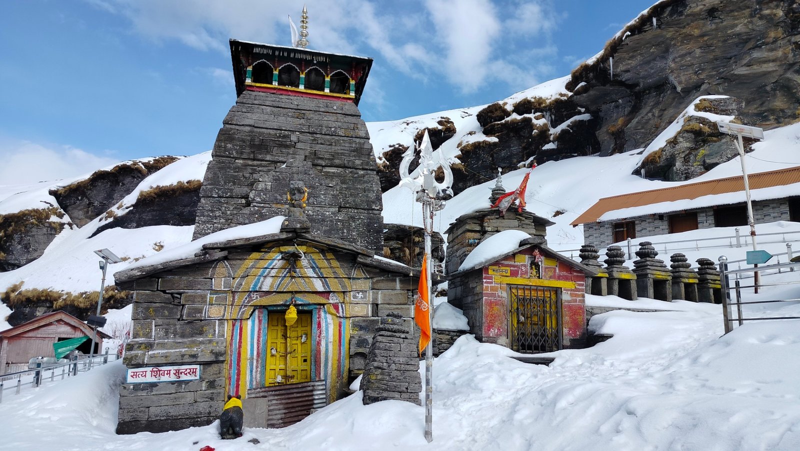
Chopta gradually falls away behind you. Forest gives way to open slopes. On a clear day, the mountains begin appearing across the horizon rather than only above the road. And eventually, after one final stretch of climbing, the stone structure of Tungnath comes into view.
For some people, that is the end of a trek.
For others, it is the arrival at one of the most important Shiva shrines in Garhwal.
And for those continuing another 1.5 kilometres towards Chandrashila, Tungnath is only where the final climb begins.
Orientation
Know the place
Tungnath is situated in Uttarakhand's Rudraprayag district on Chandranath Parvat at an altitude of about 3,680 metres. It forms part of the Panch Kedar, the five revered Shiva temples of Garhwal. According to the traditional Panch Kedar legend, Tungnath is associated with the place where the arms of Lord Shiva appeared.
The usual trek begins at Chopta, a high-altitude meadow and road-accessible settlement on the route connecting the Ukhimath side of Rudraprayag with Gopeshwar. Chopta itself is surrounded by forests and bugyals and acts as the practical base for both the Tungnath and Chandrashila climbs.
You will see different figures quoted for the Chopta–Tungnath distance. Uttarakhand Tourism describes the trail as approximately 3 km on one trekking itinerary, around 3.5 km on its Chopta destination page and approximately 4 km in its Panch Kedar information. For actual trip planning, it is safest to think of Tungnath as roughly a 3.5–4 km uphill trek one way, because the exact figure changes depending on where the distance is measured from.
From Tungnath, Chandrashila is approximately another 1.5 km uphill. That extension is considerably steeper and turns a relatively short temple trek into a more demanding outing.
02 · Why it matters
More than a point on the map
Tungnath works because the pilgrimage and the walk cannot really be separated.
There is no road ending directly beside the temple. Everyone who reaches Tungnath under normal conditions has had to climb towards it.
That changes the arrival.
You may begin at Chopta talking with friends, stopping for photographs and calculating how much distance remains. Higher up, conversations usually become shorter. People naturally spread out according to their walking pace. Someone who started behind you overtakes. Someone who rushed ahead is now sitting beside the trail.
By the time the temple finally appears, you have earned some distance from the road.
The setting matters too. Chopta is known for its meadows, forest and birdlife, while the higher trail opens towards major Himalayan ranges. Uttarakhand Tourism notes views towards peaks including Chaukhamba, Nanda Devi and other prominent mountains from the Tungnath–Chandrashila route.
Yet Tungnath should not be reduced to a scenic trekking checkpoint.
It remains an active Shiva temple and one of the Panch Kedar. People walking beside you may not regard themselves as trekkers at all. For them, every uphill step is part of a pilgrimage.
That mixture—trekkers, pilgrims, first-time mountain visitors and local people moving along the same path—is one of the things that gives Tungnath its particular character.
04 · Plan
Plan smart, travel easy
How to reach
By road
The road journey ends at Chopta, from where the trek to Tungnath begins. Chopta lies on the motorable route connecting the Ukhimath side with Gopeshwar. Travellers approaching from Rishikesh normally continue through the Garhwal hills towards Rudraprayag and then onwards towards Ukhimath/Chopta. Uttarakhand Tourism lists road connections to Chopta from places including Rishikesh, Srinagar, Rudraprayag, Ukhimath and Gopeshwar. Try to reach Chopta or nearby Baniyakund the previous evening. Driving for several hours and immediately beginning the Tungnath climb is possible, but it makes a straightforward trek unnecessarily tiring.
By train
Uttarakhand Tourism lists Rishikesh as the nearest railway station for Chopta, at approximately 202 km by road. From Rishikesh, the journey continues through the Garhwal hills by taxi, bus or a combination of local transport.
Do not plan this as if 200 km of mountain road will take the same time as 200 km on a highway. Keep most of the day available for the road journey.
By air
Jolly Grant Airport near Dehradun is the nearest major airport used for the Chopta route. Uttarakhand Tourism places Chopta approximately 221 km from Jolly Grant Airport and notes that the onward journey is by motorable road.
If arriving by flight, it is more comfortable to keep the trek for the following morning rather than trying to combine the flight, long mountain drive and Tungnath climb in one day.
Best time to visit
Late April to June
This is one of the most practical periods for the Tungnath pilgrimage trek.
As the region moves out of winter, conditions generally become more suitable for regular trekking and temple visits. Days are longer than in winter, the trail becomes easier to walk once snow retreats, and May–June is a popular period for pilgrims.
Temple opening dates are determined each year, so if darshan inside Tungnath Temple is essential to your journey, check the official seasonal opening before travelling rather than assuming that a particular April date will always be suitable.
Spring also brings rhododendron colour to parts of the wider Chopta landscape.
July to August
The monsoon makes Chopta exceptionally green, but this is not the season to build a rigid itinerary.
Rain can make the stone trail slippery, clouds can remove mountain views within minutes and road conditions in Garhwal can change after heavy rainfall.
Uttarakhand Tourism itself includes Chopta–Chandrashila among monsoon trekking landscapes, but describes the route as a moderate trek. The beauty of the season should not be confused with predictable trekking conditions.
If travelling during monsoon, check the weather forecast and road situation immediately before leaving.
September to October
For most first-time visitors, this is arguably the best overall period.
The heavy monsoon has usually withdrawn, visibility can be excellent, and temperatures remain manageable during the day. September and October also allow you to experience Tungnath as both a trek and an active pilgrimage before the winter closure.
Start early because mountain weather can still change quickly.
November to March
This is a completely different Tungnath.
Snow can cover the route heavily during winter. Uttarakhand Tourism notes that the Chopta–Tungnath–Chandrashila trail can become completely buried under snow, turning what is a straightforward paved pilgrimage route in warmer months into a genuine winter trek.
The temple itself is seasonal and closes for winter. So there is an important distinction:
Winter trek to Tungnath area ≠ regular Tungnath temple pilgrimage.
If your objective is snow trekking, travel with proper winter equipment and local knowledge.
If your objective is darshan, visit during the temple's open season.
People & place
Food and local culture
Do not arrive at Chopta expecting a large hill-station market.
The Tungnath route is part of a high-altitude pilgrimage and trekking landscape, and food around Chopta, Baniyakund and the trail is usually practical rather than elaborate: tea, parathas, Maggi, dal-rice and other straightforward mountain-road meals.
That simplicity actually suits the trek.
Eat properly before starting but avoid an excessively heavy breakfast. Carry water and something small to eat, particularly if you are continuing to Chandrashila.
During busy pilgrimage months, temporary and seasonal food options may be available along parts of the route. Their presence should never be treated as guaranteed, especially very early in the morning, late in the season or outside the main pilgrimage period.
Tungnath is also part of the wider religious landscape of Panch Kedar. According to the traditional legend, the five shrines mark different manifestations of Shiva after the Pandavas sought him in the Himalayas. Tungnath is associated with Shiva's arms.
Even if you are here mainly for trekking, remember that the person walking slowly ahead of you may be undertaking a religious journey rather than a recreational climb.
Before you leave
Plan with care
Useful notes
- Start early. This is the single most useful Tungnath trek tip. Early mornings mean cooler climbing conditions, more time at the temple and enough margin if you decide to continue towards Chandrashila.
- Treat the trek as roughly 3.5–4 km one way. Official sources themselves use slightly different measurements, so do not obsess over a single exact kilometre figure.
- Difficulty: Moderate for the average traveller. The trail is well defined and does not require technical climbing, but it climbs steadily at high altitude. Fitness matters more than trekking experience.
- Do not judge difficulty only by distance. Four kilometres uphill at altitude can feel much harder than the same distance on level ground.
- Walk at a pace at which you can still speak comfortably. Starting too fast is one of the easiest ways to make the second half unpleasant.
- Carry a light rain layer even outside peak monsoon. Mountain conditions can change quickly.
- Use shoes with reliable grip. The paved sections can become surprisingly slippery when wet.
- Carry water, but do not overload yourself. A heavy backpack provides little benefit on a short day trek.
- Wear layers rather than one heavy jacket. You may feel warm while climbing and cold very quickly when you stop.
- Protect yourself from the sun. High altitude, cool air and cloud cover can make people underestimate exposure.
- If continuing to Chandrashila, reassess yourself at Tungnath. Chandrashila is another roughly 1.5 km and significantly steeper. Reaching Tungnath does not obligate you to continue.
- Keep enough time for the descent. Do not begin the Chandrashila extension late simply because the distance looks small on a map.
- Check the annual temple opening and closing dates separately. The trekking landscape and the temple's darshan season are not the same thing.
Things to avoid
- Do not call this an “easy trek” simply because the path is paved. The altitude and continuous climb are what make Tungnath tiring.
- Do not start the trek late in the afternoon. Weather, fatigue and fading daylight can turn a simple outing into an avoidable problem.
- Do not continue towards Chandrashila automatically. If someone in your group is exhausted, dizzy, unusually breathless or unwell at Tungnath, descending is the sensible decision.
- Do not underestimate winter conditions. Snow can completely cover the normal trail.
- Avoid walking on exposed snowy sections without appropriate footwear and local assessment of conditions.
- During monsoon, do not continue simply because other people are climbing. Rain, poor visibility and slippery stone affect different walkers differently.
- Do not leave bottles, food packets or disposable rain covers on the trail. Whatever you carry up should come back down with you.
- Do not play loud music while trekking. This is both a mountain environment and an active pilgrimage route.
- Do not crowd the temple entrance for photographs. Complete darshan first and respect people who have climbed specifically for worship.
- Do not rely blindly on social-media videos for current snow or trail conditions. A video uploaded today may have been recorded weeks earlier.
07 · Make it yours
Suggested itinerary
- Day 1 – Reach Chopta / Baniyakund: Travel towards Chopta through Rudraprayag and Ukhimath, depending on your approach route. Reach before evening if possible, check into a stay around Chopta or Baniyakund, eat early and keep the night quiet. Confirm the next morning's weather and current trail conditions before sleeping.
- Day 2 – Chopta to Tungnath and Chandrashila if conditions allow: Begin early from Chopta and walk at a steady pace towards Tungnath. Keep roughly two to three hours available for a relaxed climb rather than treating the trek as a race. Spend time at Tungnath Temple. If the weather is stable, daylight is sufficient and everyone in the group feels comfortable, continue the additional approximately 1.5 km to Chandrashila. Return to Chopta with plenty of daylight remaining.
A final note
Tungnath is a useful reminder that trek difficulty cannot always be understood from a map.
Three-and-a-half or four kilometres sounds small.
Standing at Chopta, it can look small too. The trail is obvious, the destination feels close and people of every age seem to be starting alongside you.
Then the mountain establishes its own scale.
You climb one bend and find another. You stop for water and realise how much height you have already gained. The crowd that began together slowly separates into individual walkers.
And somewhere during that climb, the question usually changes from:
“How much distance is left?”
to:
“Is that Tungnath?”
When the temple finally appears above the trail, it does not require a dramatic introduction.
You already understand why it was built in a place people have to walk towards.
If you still have strength, Chandrashila waits higher up.
If you do not, there is nothing incomplete about stopping at Tungnath.
Sometimes knowing where to stop is also part of travelling well.
No approved comments yet. Be the first to share your thoughts.